

Nicholas upgraded to hurricane as it heads for Texas Gulf Coast
Nicholas strengthened into a Category 1 hurricane Monday as it headed toward landfall along the Texas Gulf Coast and it was expected to bring heavy rain and floods to coastal areas from Mexico to storm-battered Louisiana.
Forecasters at the National Hurricane Center in Miami said top sustained winds reached 75 mph (120 kph). It was traveling north-northeast at 10 mph (17 kph) on a forecast track to pass near Matagorda Bay in the upper Texas Gulf Coast later Monday, then move onshore along the Southeast Texas coast into Tuesday evening.
Heavy rainfall will impact parts of southeastern Texas, Louisiana and southern Mississippi through the middle of the week, according to the NHC.
"The Texas coast from Port O'Connor north to Freeport has been upgraded to a Hurricane Warning," the NHC tweeted Monday night.
A tropical storm warning was issued for Port Aransas to Sabine Pass, as well as a storm surge warning for Port Aransas to Sabine Pass, including Galveston, Aransas, San Antonio and Matagorda bays. A storm surge watch is in effect from Sabine Pass to Rutherford Beach, Louisiana.
Earlier on Monday, the system was expected to generate only a fraction as much rain as Harvey, nearly all of the state’s coastline was under a tropical storm warning that included potential flash floods and urban flooding. Texas Gov. Greg Abbott said authorities placed rescue teams and resources in the Houston area and along the coast.
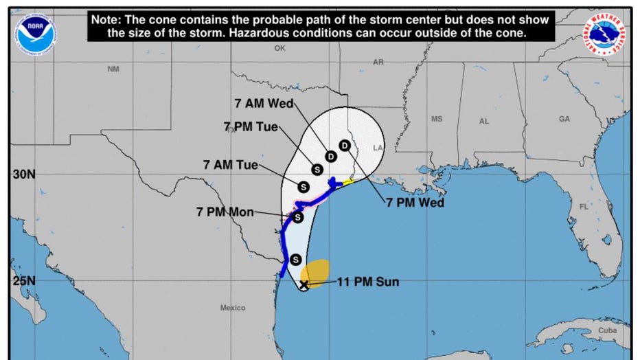
This image provided by NOAA shows the predicted path of Tropical Storm Nicholas, as of early Monday. (Credit: NOAA)
"Nicholas is forecast to approach the middle Texas coast as a strong tropical storm by this evening and could be near hurricane intensity at landfall," the NHC said.
RELATED: Tropical Storm Nicholas strengthens to 70 miles per hours, expected to make landfall late tonight
At dusk Monday, Nicholas was centered roughly 35 miles (60 kilometers) south-southwest of Matagorda, Texas, and a hurricane watch was issued from Port Aransas to San Luis Pass.
Six to 12 inches (15 to 30 centimeters) of rain were expected along the middle and upper Texas coast, with isolated maximum amounts of 18 inches (46 centimeters) possible. Other parts of southeast Texas and south-central Louisiana and southern Mississippi could see 4 to 8 inches (10 to 20 centimeters) over the coming days.
"Significant rainfall amounts are possible, potentially resulting in areas of considerable flash and urban flooding, especially in highly urbanized metropolitan areas," the NHC said.
Several schools in the Houston and Galveston area were closed Monday because of the incoming storm.
"This is a storm that could leave heavy rain, as well as wind and probably flooding, in various different regions along the Gulf Coast. We urge you to listen to local weather alerts, heed local warnings," Abbot said in a video message.
Louisiana Gov. John Bel Edwards on Sunday night declared a state of emergency ahead of the storm's arrival in a state still recovering from Hurricane Ida and last year's Hurricane Laura and historic flooding.
"The most severe threat to Louisiana is in the southwest portion of the state, where recovery from Hurricane Laura and the May flooding is ongoing. In this area heavy rain and flash flooding are possible. However, it is also likely that all of south Louisiana will see heavy rain this week, including areas recently affected by Hurricane Ida," Edwards said.
The storm was expected to bring the heaviest rainfall west of where Hurricane Ida slammed into Louisiana two weeks ago. Although forecasters did not expect Louisiana to suffer from strong winds again, meteorologist Bob Henson at Yale Climate Connections predicted rainfall could still plague places where the hurricane toppled homes, paralyzed electrical and water infrastructure and left at least 26 people dead.
"There could be several inches of rain across southeast Louisiana, where Ida struck," Henson said in an email.
RELATED: Abbott holds briefing as Texas braces for Tropical Storm Nicholas
Immediately after Ida, more than one million customers across Louisiana and Mississippi had been left without power. Across Louisiana, just over 115,000 customers remained in the dark early Monday, according to the utility tracking site poweroutage.us.
While Lake Charles received a minimal impact from Ida, the city saw multiple wallops from Hurricane Laura and Hurricane Delta in 2020, a winter storm in February as well as historic flooding this spring.
"We are still a very battered city," Lake Charles Mayor Nic Hunter said.
He said the city is taking the threat of the storm seriously, as it does all tropical systems.
"Hope and prayer is not a good game plan," Hunter said.
Nicholas is the 14th named storm of 2021 Atlantic hurricane season, according to Colorado State University hurricane researcher Phil Klotzbach. Only four other years since 1966 have had 14 or more named storms by Sept. 12: 2005, 2011, 2012 and 2020.
This story was reported from Cincinnati. The Associated Press contributed.