

Hurricane Zeta surges inland, causing flooding, power outages along Gulf Coast

NEW ORLEANS (AP) - An air Force Reserve Hurricane Hunter aircraft indicated that Hurricane Zeta made landfall near Cocodrie, Louisiana with maximum sustained winds around 110 mph Wednesday afternoon.
Zeta slammed into storm-weary Louisiana on Wednesday, pelting the New Orleans metro area with rain and howling winds that ripped apart buildings, knocked out power to thousands and threatened to push up to 9 feet of sea water inland in a Gulf Coast region already pounded by multiple storms this year.
St. Bernard Parish President Guy McInnis said emergency workers were doing their best to respond to reports of people in distress after their roofs were blown off.
“Guys, we received the brunt of Zeta, and Zeta gave us a good punch,” McInnis told WDSU-TV.

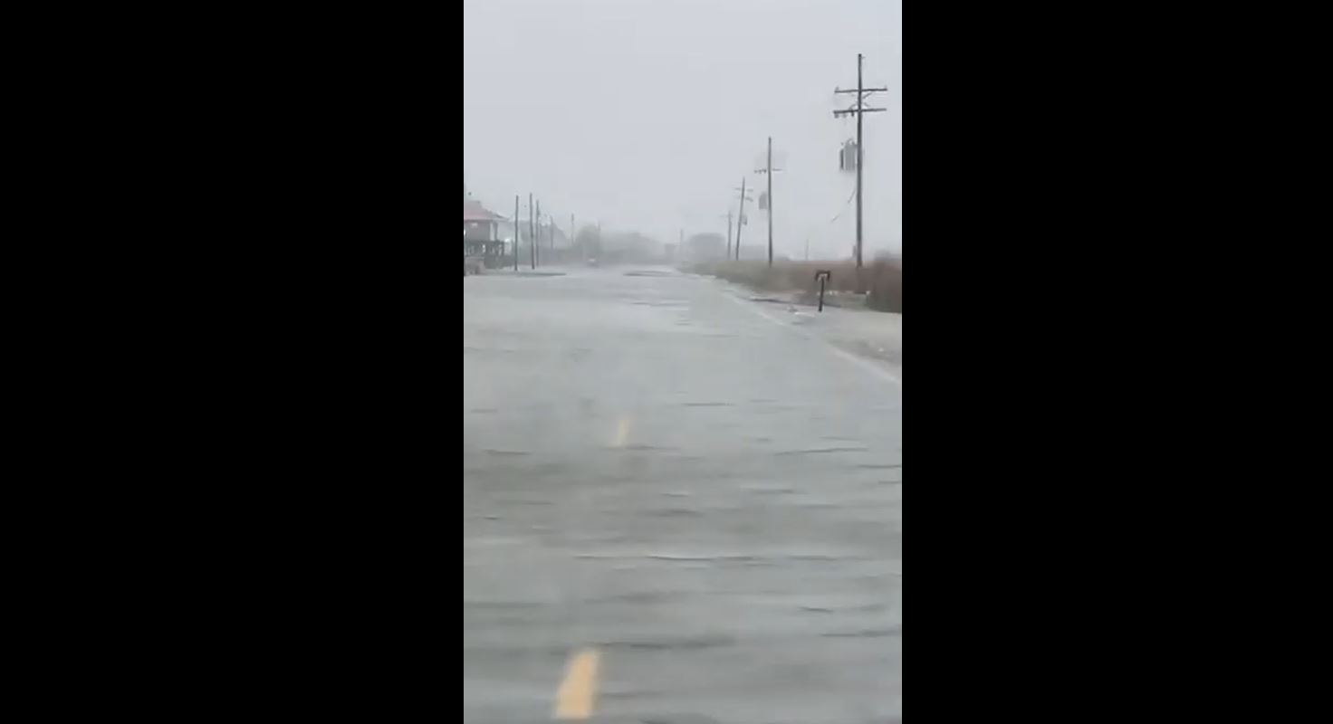
Roads were flooded near the coast, where forecasters said Zeta made landfall around Terrebone Bay near Cocodrie, an unincorporated fishing village at the end of a highway with few if any full-time residents and a marine laboratory where a building was inundated.
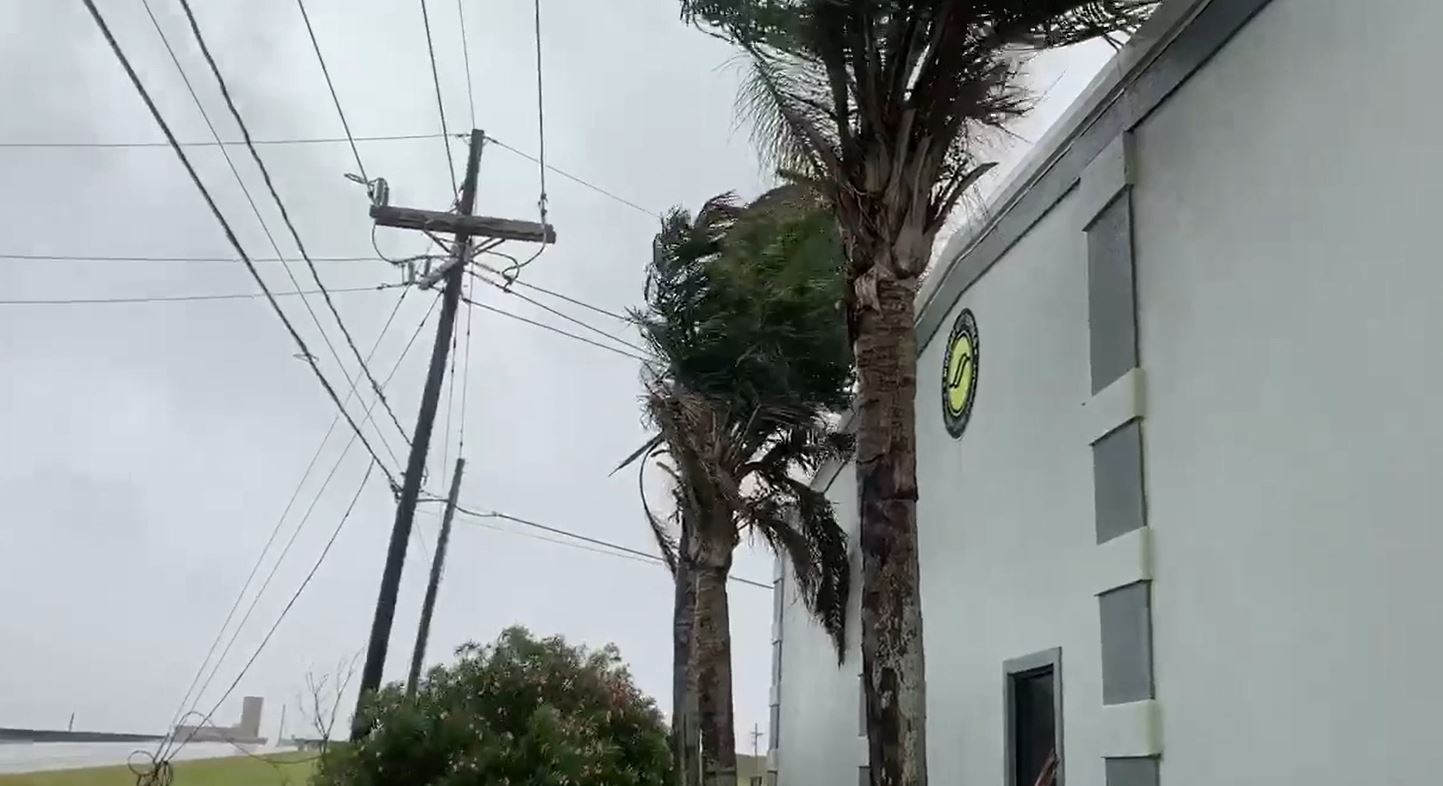
Streams of rainfall ran off roofs in New Orleans' famed French Quarter, signs outside bars and restaurants swayed back and forth in the wind and palm trees along Canal Street whipped furiously. A few trees were down, and one that fell across utility lines sparked a bright orange flash. Officials said a person was hospitalized with minor injuries after a structure collapsed, but further details weren't available.
Nearly 400,000 customers were without electricity in Louisiana and Mississippi, including more than 280,000 in metro New Orleans. More outages were feared overnight as the storm moves northeastward across the Deep South.
Zeta had top sustained winds of 110 mph (177 kph) as a Category 2 hurricane and was the 27th named storm of a historically busy Atlantic hurricane season — with over a month left before it ends. It set a new record as the 11th named storm to make landfall in the continental U.S. in a single season, well beyond the nine storms that hit in 1916.
Winds decreased slightly to 100 mph a few hours after landfall, but forecasters said remained a life-threatening storm.
Hurricane Zeta was speeding toward storm-weary Louisiana with top winds of 90 mph (150 kph), forecast to strike the coast as a Category 2 hurricane Wednesday afternoon. New Orleans, where a pump system failure raised flood risks, was squarely in its path.

Workers closed one of the last floodgates surrounding the city as residents braced for the 27th named storm of a historically busy Atlantic hurricane season. The iconic streetcars shut down and City Hall closed until after the storm, Mayor LaToya Cantrell said.
Tropical storm warnings were issued as far away as the north Georgia mountains, highly unusual for the region. New Orleans has been in the warning areas of seven previous storms that veered east or west this season. Zeta was staying on course.
“I don’t think we’re going to be as lucky with this one,” city emergency director Collin Arnold said.
RELATED: New Orleans braces for hurricane as Zeta swirls over Mexico
Zeta had been predicted to hit as a relatively weak Category 1 hurricane, but Louisiana residents awoke to updated forecasts predicting a Category 2, intensifying to nearly 100 mph (160 kph) at landfall.
“The good news for us -– and look, you take good news where you can find it –- the storm’s forward speed is 17 mph. That’s projected to increase, and so it’s going to get in and out of the area relatively quickly, and then we’re going to be able to assess the damage more quickly,” Gov. John Bel Edwards said in an interview on The Weather Channel.
Officials urged people to take precautions and prepare to shelter in place, but there were few signs of concern in New Orleans. It was business as usual in the French Quarter. “This one is moving fast and I don’t think it’s going to do much,” said Kelly Ann, a visitor from St. Petersburg, Florida, as she strolled Decatur Street.
The winds were picking up and water was rising above the docks in Jean Lafitte, a small fishing town south of New Orleans that takes its name from a French pirate. Workers drove truckloads of sand to low-lying areas where thousands of sandbags were already stacked before previous storms.
“We’re going to get a lot of water fast,” said the mayor, Tim Kerner Jr. “I’m optimistic regarding the tidal surge because of the speed of the storm, but we’re not going to take it for granted.”
RELATED: Hurricane Zeta: Wind, rain lash Mexico coast as storm nears
New Orleans officials announced that a turbine that generates power to the city’s aging drainage pump system broke down on Sunday, with no quick repair in sight. There was enough power to keep the pumps operating if needed, but little excess power to tap if other turbines fail, officials said.
Officials said they were running through contingencies to provide power and make repairs where needed should there be other equipment problems. Forecasts called for anywhere from 2 to 6 inches (5 to 15 centimeters) of rain to fall in the New Orleans area, but Zeta is expected to be a relatively fast-moving storm, possibly mitigating the flood threat.
By late Wednesday morning, Zeta’s top winds had grown to 90 mph (150 kph) and its forward movement increased to 18 mph (28 kph) as its center moved north, about 235 miles (380 kilometers) south of New Orleans.
Zeta raked across Mexico's Yucatan Peninsula Tuesday, toppling trees and briefly cutting power to more than 300,000 people but causing no deaths, before strengthening again along a path slightly east of Hurricane Laura, which was blamed for at least 27 Louisiana deaths after it struck in August, and Hurricane Delta, which exacerbated Laura’s damage in the same area just weeks later.
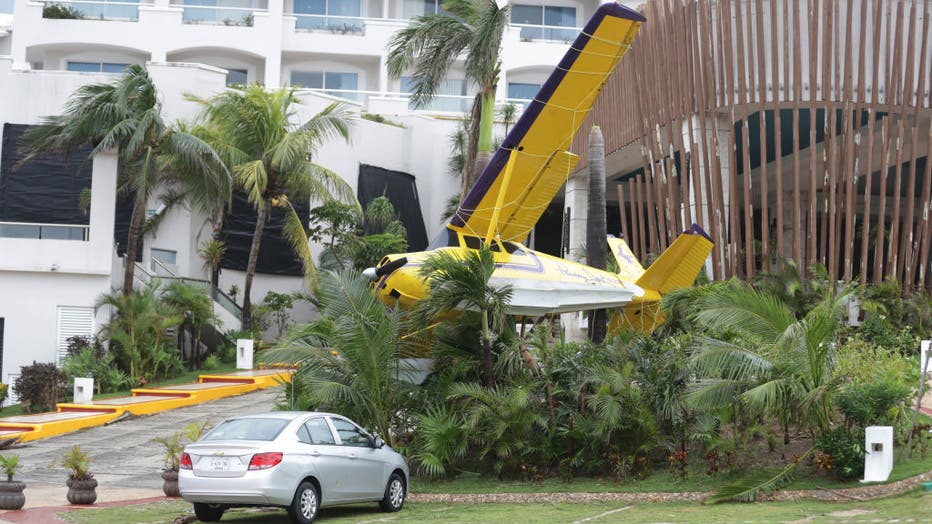
A plane that adorned the entrance of a hotel fell due to the strong gusts of wind of 130 kilometers per hour, by the arrived of the Hurricane Zeta in category 1 of the Saffir-Simpson scale. (Photo credit: Rodolfo Flores / Eyepix Group/Barcroft Media
Hurricane warnings stretched from Morgan City, Louisiana to the Alabama/Mississippi state line, including Lake Pontchartrain and metropolitan New Orleans. The deteriorating weather forced early voting sites to close for hours in the western Florida Panhandle, where Republicans dominate.
Tropical storm warnings covered a large swath of the South, from Louisiana and Mississippi into Alabama and Georgia, including all of the Atlanta area, where winds could gust up to 55 mph (89 kph) early Thursday. Winds could be “especially severe” in the southern Appalachian Mountains, where flash flooding is possible, the hurricane center said.
Edwards asked President Donald Trump for a disaster declaration ahead of the storm. He and Alabama Gov. Kay Ivey both declared emergencies, as did Mayor Andrew “FoFo” Gilich in Biloxi, Mississippi. Trump declared an emergency for Louisiana Tuesday evening.
An average season sees six hurricanes and 12 named storms. This extraordinarily busy season has focused attention on climate change, which scientists say is causing wetter, stronger and more destructive storms.
“I’m physically and mentally tired,” a distraught Yolanda Lockett of Lake Charles said outside her New Orleans hotel. She's one of about 3,600 evacuees from Laura and Delta still sheltering.
In coastal St. Bernard Parish, Robert Campo readied his marina for another onslaught. "We’re down for four or five days, that’s four or five days nobody’s fishing. That’s four or five days nobody is shrimping. That’s four or five days, no economic wheels are turning,” he said.
After Hanna, Isaias, Laura, Sally and Delta, Zeta will tie a record set in 1886 and repeated in 1985 for six hurricanes smacking the continental U.S., according to Colorado State University hurricane researcher Phil Klotzbach.
And as the 11th named storm to make landfall in the continental U.S., Zeta will set a new record, well beyond the nine storms that hit in 1916.